Fetch Me A Breeze Please!
Fetch is a nautical term meaning the distance
over which wind-driven waves travel without encountering
obstructions. The longer the fetch, the more powerful the waves!
When those long-fetched waves finally pound up against the
shoreline? That, my friend, should be a bass-laden location...
and you should be fishing those spots whenever it's windy!
What's that you say? You don't know any
good spots to fish in the wind? Well, just climb on board, don
your windbreaker, and let's take an imaginary boat ride on
Internet Lake! We'll try to locate some really windy hotspots for
you where bass come up to aggressively feed whenever it is windy!
No, we don't have a GPS to navigate on
Internet Lake, but we have something even better for our
computerized excursion - USGS charts downloadable from Microsoft's
TerraServer! These charts are just about the best tools an
e-angler can use to study fishing spots both far and near. Any
USGS-charted body of water can be navigated with a few
mouse-clicks and downloaded onto your computer. A person who
knows how to use an image editor (or even Microsoft Word), can
annotate the maps with comments and mark hotspots on them as you
see I've done below. Best of all, TerraServer usage is FREE!
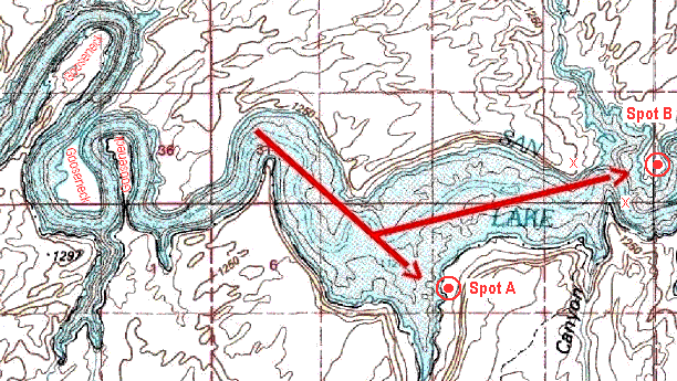
On our first windchart, the three
elliptical goosenecks in the upper left are narrow, necked-down
and circuitous areas. There are no readily-identifiable windward
shorelines in these goosenecks. Now study how the water widens
with a lengthy run of unobstructed wind-driven waves crashing
onto the open exposed shoreline of Spot A. Spot B also has
a long run (several miles) of wide open water and wind-driven
waves being funneled and forced through the constriction marked
by the two X's before battering against Spot B.
 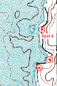 When we drive the
boat into Spot A, we see it is actually an island and the
promontory of an underwater point extending out from the
mainland. We also see a very pale brown line extending
around the outside of the island, and then the line parallels up
and down the main shoreline. No doubt, this island is a rocky
reef, and all the area contained between the brown lines behind
it is likely to be a boulder field extending back to the main
shoreline! The island, the boulder field extending to shore and
the main shoreline behind the island should all hold plenty of
bass that get the "need to feed" in the wind. Below
Spot A, we see a wind-battered bay which may develop a mud-line
close in to shore that harbors some feisty largemouth! Below the
wind-battered bay, there is another wind-exposed point - a
classic smallmouth point well worth trying before we fire up the
big engine to scout Spot B. When we drive the
boat into Spot A, we see it is actually an island and the
promontory of an underwater point extending out from the
mainland. We also see a very pale brown line extending
around the outside of the island, and then the line parallels up
and down the main shoreline. No doubt, this island is a rocky
reef, and all the area contained between the brown lines behind
it is likely to be a boulder field extending back to the main
shoreline! The island, the boulder field extending to shore and
the main shoreline behind the island should all hold plenty of
bass that get the "need to feed" in the wind. Below
Spot A, we see a wind-battered bay which may develop a mud-line
close in to shore that harbors some feisty largemouth! Below the
wind-battered bay, there is another wind-exposed point - a
classic smallmouth point well worth trying before we fire up the
big engine to scout Spot B.
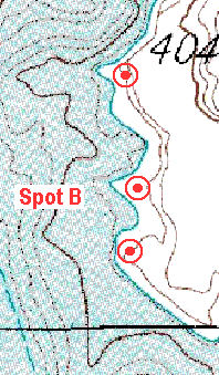
Spot B also reveals itself to be a series of
wave-beaten points and bowls as we get closer to it. Again,
expect smallmouth on the points of Spot B, extending as far out
offshore as the barely-visible thin brown contour line, which is
an underwater ledge line. Expect largemouth tucked up tight to
shore in the very dead-centers of the wind-beaten bowls, on the
edges of any mud lines kicked up by the incessant wave action.
As we continue to journey further up Internet
Lake, we again run through a narrow, winding section on the
left of our chart which has no obvious windward shoreline. That
is, until we come clear of the last bend and the lake widens once
again into a section with plenty of fetch (remember, fetch is the
distance over which wind-blown waves travel without encountering
obstructions). On the chart, the red arrows (which show the
direction the wind blows) are bending around to follow the
contours of the shoreline. This is exactly what the real wind
will do - bend around any shoreline which has bluffs. After all,
air is fluid like water, and air will bend and flow like water
does, conforming its direction and speed to the contours of the
topography.
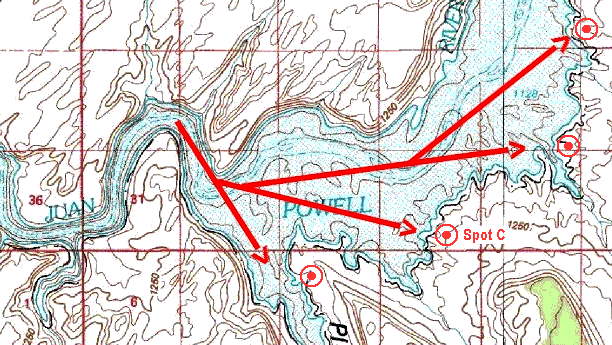
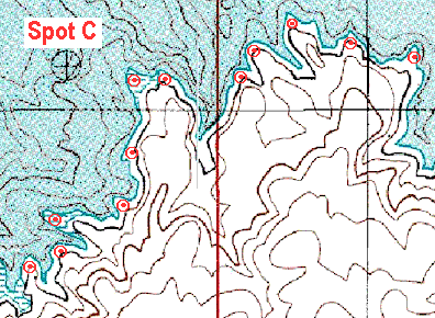 As we come off plane and idle
into Spot C, we see it's a virtual "windy
wonderland" of smallmouth-stacked points and
largemouth-filled cuts and coves. In fact, there can be no doubt
from our TerraServer USGS charts that the entire shoreline of
Internet Lake for many miles above and below Spot C is the same
heavily-corrugated shoreline! With the many ins and outs of the
shoreline above and below Spot C, it would probably take us
about one week to fish all of this massive mega-spot properly!
Hey, do you think we can get a wind that will blow hard for the
next seven days? As we come off plane and idle
into Spot C, we see it's a virtual "windy
wonderland" of smallmouth-stacked points and
largemouth-filled cuts and coves. In fact, there can be no doubt
from our TerraServer USGS charts that the entire shoreline of
Internet Lake for many miles above and below Spot C is the same
heavily-corrugated shoreline! With the many ins and outs of the
shoreline above and below Spot C, it would probably take us
about one week to fish all of this massive mega-spot properly!
Hey, do you think we can get a wind that will blow hard for the
next seven days?
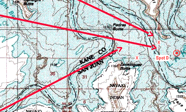
Okay, it's one week later, and we're
cruising yet another virtual section of the seemingly endless
expanse known as Internet Lake. We've already learned a lot about
how to locate "wind spots" using our TerraServer topo-mapping
system. So it is an obvious and familiar situation we now study
the map for...and find! It's a very wide basin to the left, wind
bending around the topography, and funneling long-fetched waves
between the constricted area marked by the two X's. Now, we've
found the topography we want! Next, let's zoom into the area just
downwind of the two X's hoping to find a sweet spot. Hmmm? You
see the brown topo line extending out as an underwater point well
off the mainland? It's a clue, suspicious and promising to scout
around for an elusive Spot D, typically a high spire or
tower-like rise at the promontory of that underwater point!
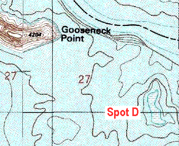 As we zoom in to cruise
around...lo and behold! Spot D appears to be a brush-filled
reef and no doubt a rock-rubble strewn one too if it has been
able to survive being pounded by what appears to be the most
wind-exposed spot we have found yet. Looking at the map, there
can be no doubt this brush reef must literally crawl with
largemouth that mysteriously emerge out of the depths here for an
all-out feeding frenzy whenever they feel a stiff wind smearing
whitecaps across the surface! As we zoom in to cruise
around...lo and behold! Spot D appears to be a brush-filled
reef and no doubt a rock-rubble strewn one too if it has been
able to survive being pounded by what appears to be the most
wind-exposed spot we have found yet. Looking at the map, there
can be no doubt this brush reef must literally crawl with
largemouth that mysteriously emerge out of the depths here for an
all-out feeding frenzy whenever they feel a stiff wind smearing
whitecaps across the surface!
Now, Spots A, B and C are all at the very end of
a fetch where all of the power of the waves is ultimately
delivered. This is a fundamental concept to me in finding
predictable wind spots - that the fetch stops there. However,
Spot D is not like A, B and C in that the waves continue on past
Spot D...it is like a brick wall dropped smack in the middle of
the wave's fetch! This doesn't make Spot D any better or worse of
a hotspot, but it does make such spots less predictable to find
using TerraServer.
Spot E is one of the last places we'll try
today. The two arrows illustrate the possibility that wind
may blow into Spot E from either of two different directions at
different times. In either case, Spot E is also different from A,
B and C in that Spot E is not the end of the fetch, but actually
a "turning point" where the wind will bank around this
turn and continue on down the other side. Now, although this is a
bend, the waters off Spot E are actually quite wide and open, not
at all like the narrow circuitous goosenecks preceding Spot A or
Spot C. Now at this map resolution, Spot E just appears like a
mild bump being kissed by the outside bend of the main channel...
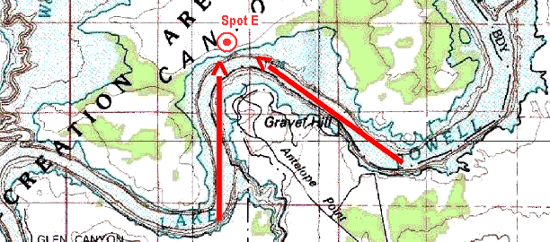
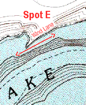 ...but when we pull up on Spot
E, a protruding main channel point materializes, along with
what I call a "wind lane" because the wind channels
past the outside edge of this point in a lateral direction,
regardless of whether the wind's blowing from left or right. Now,
wind lanes usually equate to feeding lanes. As the wind
starts to flow the water past them, fish take feeding stations on
bottom in the wind-driven current and wait to see what tender
morsels come blowing by them in the moving water. Usually, wind
gets everything moving, and the map is marked with an arrow
showing the length of drift to be made from either direction,
keeping in mind this is not only a nice point, but it's also the
dead center of the outside bend of the main channel...always a
great place to fish! ...but when we pull up on Spot
E, a protruding main channel point materializes, along with
what I call a "wind lane" because the wind channels
past the outside edge of this point in a lateral direction,
regardless of whether the wind's blowing from left or right. Now,
wind lanes usually equate to feeding lanes. As the wind
starts to flow the water past them, fish take feeding stations on
bottom in the wind-driven current and wait to see what tender
morsels come blowing by them in the moving water. Usually, wind
gets everything moving, and the map is marked with an arrow
showing the length of drift to be made from either direction,
keeping in mind this is not only a nice point, but it's also the
dead center of the outside bend of the main channel...always a
great place to fish!
One last word of caution. Somewhere around
20 knots, it becomes extremely dangerous to attempt fishing any
wind-swept, wave-slapped point, reef or main shoreline at the end
of a fetch. But even at lower wind speeds, you must always leave
room to get out of harm's way in an instant! Wear your life
jackets! Maintain a safe distance and have an escape route ready
for when a rogue gust or big series of waves or boat wakes tries
to overwhelm you. Trust me, it will overwhelm you if you are not
constantly ready with a way to immediately turn out of there! The
most careless point comes when you hit a big fish in the wind,
become pre-occupied with landing it. NOT the time to turn your
back and wrestle with prying out those trebles. NOT the time to
take a photo! It IS the time to turn out of there into open water
until the fish is fully-dispatched, your tackle's squared away,
and you can fully-focus on boat positioning again. Turn your back
an instant, and it won't take more than 1 or 2 rogue swells to
roll you over on the curved knee of a sloping bluff. Stray a
second too close, and it won't take too many 2 to 3 foot waves to
jackhammer your boat up and down on a barely-submerged boulder
and split the bottom open. Your 107 lb. thrust trolling motor
will not get you out of there when that happens! Regardless of
any warning, enticement or advice given in this article, only you
are the one personally responsible for your own safety and the
safety of your passengers. For the avid enthusiast, Mother Nature
can make bass fishing an occasionally extreme and exhilarating
outdoor sport, along with all the required precautions. If you
agree with this statement, then you probably already understand
the degree of safety, experience and skill required by the avid
bass boating enthusiast. And if you don't agree with this
statement, then please stay at the dock when the wind blows!
Today, we've demonstrated the power of
TerraServer to locate, to download and to mark hotspots on any
available USGS-charted lake. Plus, we've talked some about the
wind and the waves, and the excitement and exhilaration of
fishing in them! I think it's been quite fetching! How about you?
|
